


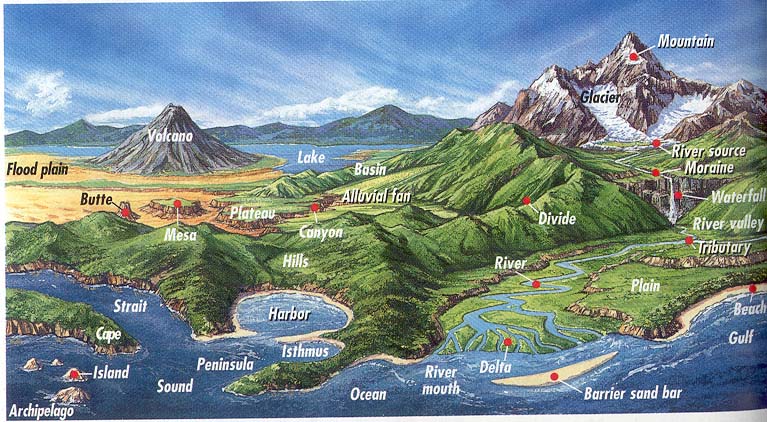
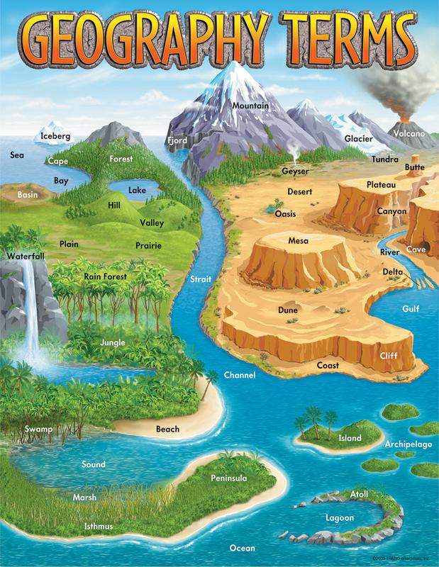
Post by Joey on Aug 24, 2020 14:32:32 GMT 10
During mapping and navigation you will come across a lot of different land formations, sometimes it helps to have a rough idea on reading them, especially when interpreting the early explorers notes.
Most of these we would of never heard of before let alone use, but I found these couple of images that show to most common names used.
Landforms by process
Landforms organized by the processes that create them.
Aeolian
Further information: Coastal geography and Physical oceanography
See also: List of submarine topographical features
Coastal and oceanic landforms include:
• Abyssal fan – Underwater geological structures associated with large-scale sediment deposition
• Abyssal plain – Flat area on the deep ocean floor
• Archipelago – A group of islands
• Atoll – Ring-shaped coral reef
• Arch – A natural rock formation where a rock arch forms
• Ayre – Shingle beaches in Orkney and Shetland
• Barrier bar
• Barrier island – Coastal dune landform that forms by wave and tidal action parallel to the mainland coast
• Bay – Recessed, coastal body of water connected to an ocean or lake
• Baymouth bar – A depositional feature as a result of longshore drift, a sandbank that partially or completely closes access to a bay.
• Beach – Area of loose particles at the edge of the sea or other body of water
• Raised beach – A beach or wave-cut platform raised above the shoreline by a relative fall in the sea level
• Beach cusps – Shoreline formations made up of various grades of sediment in an arc pattern
• Beach ridge – Wave-swept or wave-deposited ridge running parallel to a shoreline
• Bight – Shallowly concave bend or curve in a coastline, river, or other geographical feature
• Blowhole – Hole at the top of a sea-cave which allows waves to force water or spray out of the hole
• Channel – A type of landform in which part of a body of water is confined to a relatively narrow but long region
• Cape – A large headland extending into a body of water, usually the sea
• Calanque – A narrow, steep-walled inlet on the Mediterranean coast
• Cliff – A vertical, or near vertical, rock face of substantial height
• Coast – Area where land meets the sea or ocean
• Continental shelf – A portion of a continent that is submerged under an area of relatively shallow water known as a shelf sea
• Coral reef – Outcrop of rock in the sea formed by the growth and deposit of stony coral skeletons
• Cove – A small sheltered bay or coastal inlet
• Cuspate foreland – Geographical features found on coastlines and lakeshores that are created primarily by longshore drift
• Dune system – A hill of loose sand built by aeolian processes or the flow of water
• Estuary – Partially enclosed coastal body of brackish water with one or more rivers or streams flowing into it, and with a free connection to the open sea
• Firth – Scottish word used for various coastal inlets and straits
• Fjard – A glacially formed, broad, shallow inlet
• Fjord – A long, narrow inlet with steep sides or cliffs, created by glacial activity
• Geo – An inlet, a gully or a narrow and deep cleft in the face of a cliff
• Gulf – A large inlet from the ocean into the landmass
o List of gulfs – Wikipedia list article
• Headland – A landform extending into a body of water, often with significant height and drop
• Inlet – An indentation of a shoreline that often leads to an enclosed body of salt water, such as a sound, bay, lagoon, or marsh
• Island – Any piece of sub-continental land that is surrounded by water
• Islet – Very small island
• Isthmus – Narrow strip of land connecting two larger land areas
• Lagoon – A shallow body of water separated from a larger body of water by barrier islands or reefs
• Machair – A fertile low-lying grassy plain
• Marine terrace
• Mid-ocean ridge – underwater mountain system formed by plate tectonic spreading
• Oceanic basin – Large geologic basins that are below sea level
• Oceanic plateau – Relatively flat submarine region that rises well above the level of the ambient seabed
• Oceanic ridge – An underwater mountain system formed by plate tectonic spreading
• Oceanic trench – Long and narrow depressions of the sea floor
• Peninsula – Geographical feature
• Ria – A coastal inlet formed by the partial submergence of an unglaciated river valley
• River delta – Silt deposition landform at the mouth of a river
• Salt marsh – Coastal ecosystem between land and open saltwater that is regularly flooded
• Sea cave – A cave formed by the wave action of the sea and located along present or former coastlines
• Seamount – A mountain rising from the ocean seafloor that does not reach to the water's surface
• Seamount chains
• Shoal – A natural landform that rises from the bed of a body of water to near the surface and is covered by unconsolidated material
• Shore – The fringe of land at the edge of a large body of water
• Sound – A long, relatively wide body of water, connecting two larger bodies of water
• Spit – A coastal bar or beach landform deposited by longshore drift
• Strait – A naturally formed, narrow, typically navigable waterway that connects two larger bodies of water
• Strandflat – A landform typical of the Norwegian coast consisting of a flattish erosion surface on the coast and near-coast seabed
• Stack – geological landform consisting of a steep and often vertical column or columns of rock, and stump
• Submarine canyon – A steep-sided valley cut into the seabed of the continental slope
• Surge channel – A narrow inlet, usually on a rocky shoreline, and is formed by differential erosion of those rocks by coastal wave action
• Tessellated pavement – A relatively flat rock surface that is subdivided into more or less regular shapes by fractures
• Tidal marsh – Marsh subject to tidal change in water
• Tide pool – A rocky pool on a seashore, separated from the sea at low tide, filled with seawater
• Tombolo – A deposition landform in which an island is connected to the mainland by a sandy isthmus
• Volcanic arc – A chain of volcanoes formed above a subducting plate
• Wave-cut platform – The narrow flat area often found at the base of a sea cliff or along the shoreline of a lake, bay, or sea that was created by erosion
Erosion landforms
Landforms produced by erosion and weathering usually occur in coastal or fluvial environments, and many also appear under those headings.
• Arête – A narrow ridge of rock which separates two valleys
• Badlands – A type of dry terrain where softer sedimentary rocks and clay-rich soils have been extensively eroded
• Bornhardt – A large dome-shaped, steep-sided, bald rock
• Butte – Isolated hill with steep, often vertical sides and a small, relatively flat top
• Canyon – Deep ravine between cliffs
• Cave – Natural underground space large enough for a human to enter
• Cirque – An amphitheatre-like valley formed by glacial erosion
• Cliff – A vertical, or near vertical, rock face of substantial height
• Cryoplanation terrace – Formation of plains, terraces and pediments in periglacial environments
• Cuesta – A hill or ridge with a gentle slope on one side and a steep slope on the other
• Dissected plateau – Plateau area that has been severely eroded so that the relief is sharp
• Erg – A broad, flat area of desert covered with wind-swept sand
• Etchplain – A plain where the bedrock has been subject to considerable subsurface weathering
• Exhumed river channel – A ridge of sandstone that remains when the softer flood plain mudstone is eroded away
• Fjord – A long, narrow inlet with steep sides or cliffs, created by glacial activity
• Flared slope – A rock-wall with a smooth transition into a concavity at the foot zone
• Flatiron – A steeply sloping triangular landform created by the differential erosion of a steeply dipping, erosion-resistant layer of rock overlying softer strata.
• Gulch – Deep V-shaped valley formed by erosion
• Gully – Landform created by running water eroding sharply into soil
• Hogback – A long, narrow ridge or a series of hills with a narrow crest and steep slopes of nearly equal inclination on both flanks
• Hoodoo – A tall, thin spire of relatively soft rock usually topped by harder rock
• clinal ridge – Ridge with a moderate sloping backslope and steeper frontslope
• Inselberg, also known as Monadnock – Isolated rock hill or small mountain that rises abruptly from a relatively flat surrounding plain
• Inverted relief – Landscape features that have reversed their elevation relative to other features
• Lavaka – A type of gully, formed via groundwater sapping
• Limestone pavement – A natural karst landform consisting of a flat, incised surface of exposed limestone
• Mesa – Elevated area of land with a flat top and sides that are usually steep cliffs
• Mushroom rock – Naturally occurring rock whose shape resembles a mushroom
• Natural arch – A natural rock formation where a rock arch forms
• Paleoplain
• Paleosurface – A surface made by erosion of considerable antiquity
• Pediment – A very gently sloping inclined bedrock surface
• Pediplain – An extensive plain formed by the coalescence of pediments
• Peneplain – A low-relief plain formed by protracted erosion
• Planation surface – A large-scale surface that is almost flat
• Potrero – A long mesa that at one end slopes upward to higher terrain.
• Ridge – A geological feature consisting of a chain of mountains or hills that form a continuous elevated crest for some distance
• Rôche moutonnée
• List of rock formations – Links to Wikipedia articles about notable rock outcrops
• Strike ridge – Ridge with a moderate sloping backslope and steeper frontslope
• Structural bench – A long, relatively narrow land bounded by distinctly steeper slopes above and below
• Structural terrace – A step-like landform
• Tepui – A table-top mountain or mesa in the Guiana Highlands of South America
• Tessellated pavement – A relatively flat rock surface that is subdivided into more or less regular shapes by fractures
• Truncated spur – A ridge that descends towards a valley floor or coastline that is cut short
• Tor – Large, free-standing rock outcrop that rises abruptly from the surrounding smooth and gentle slopes of a rounded hill summit or ridge crest
• Valley – Low area between hills, often with a river running through it
• Wave-cut platform – The narrow flat area often found at the base of a sea cliff or along the shoreline of a lake, bay, or sea that was created by erosion
Fluvial landforms
Fluvial landforms include:
• Ait – Islands found on the River Thames and its tributaries in England
• Alluvial fan – A fan- or cone-shaped deposit of sediment crossed and built up by streams
• Anabranch – A section of a river or stream that diverts from the main channel and rejoins it downstream.
• Arroyo – A dry creek or stream bed with flow after rain
• Asymmetric valley – A valley that has steeper slopes on one side
• Backswamp – Environment on a floodplain where deposits settle after a flood
• Bar – A natural landform that rises from the bed of a body of water to near the surface and is covered by unconsolidated material
• Bayou – French term for a body of water typically found in flat, low-lying area
• Bench – A long, relatively narrow land bounded by distinctly steeper slopes above and below
• Braided channel – A network of river channels separated by small, and often temporary, islands
• Canyon – Deep ravine between cliffs
• Cave – Natural underground space large enough for a human to enter
• Cliff – A vertical, or near vertical, rock face of substantial height
• Cut bank – Outside bank of a water channel, which is continually undergoing erosion
• Crevasse splay – Sediment deposited on a floodplain by a stream which breaks its levees
• Confluence – Meeting of two or more bodies of flowing water
• Drainage basin – Area of land where precipitation collects and drains off into a common outlet
• Drainage divide – Elevated terrain that separates neighbouring drainage basins
• Endorheic basin – Closed drainage basin that allows no outflow
• Entrenched meander
• Epigenetic valley – Valley created by erosion and with little or no sympathy for bedrock structure
• Esker – Long, winding ridge of stratified sand and gravel associated with former glaciers
• Exhumed river channel – A ridge of sandstone that remains when the softer flood plain mudstone is eroded away
• Floodplain – Land adjacent to a stream or river which is flooded during periods of high discharge
• Fluvial island – Exposed land within a river.
• Fluvial terrace – Elongated terraces that flank the sides of floodplains and river valleys
• Gorge – Deep ravine between cliffs
• Gully – Landform created by running water eroding sharply into soil
• Natural levee – Ridge or wall to hold back water
• Marsh – wetland that is dominated by herbaceous rather than woody plant species
• Meander – Sinuous bend in a series in the channel of a river
• Misfit stream – a river too large or too small to have eroded the valley or cave passage in which it flows
• Oxbow lake – U-shaped lake formed by a cut-off meander of a river
• Point bar – A depositional feature of alluvium that accumulates on the inside bend of streams and rivers below the slip-off slope
• Plunge pool – Depression at the base of a waterfall created by the erosional force of falling water and rocks where it lands
• Rapid
• Riffle – Shallow landform in a flowing channel
• River – Natural flowing watercourse
• River delta – Silt deposition landform at the mouth of a river
• River island – Exposed land within a river.
• Rock-cut basin – Cylindrical depressions cut into stream or river beds
• Shut-in – A type of rock formation found in Ozarks streams
• Thalweg – Line of lowest elevation in a watercourse or valley
• Towhead – Exposed land within a river.
• Shoal – A natural landform that rises from the bed of a body of water to near the surface and is covered by unconsolidated material
• Spring – A point at which water emenges from an aquifer to the surface
• Strath – Large valley
• Stream – Body of surface water flowing down a channel
• Stream pool – A stretch of a river or stream in which the water is relatively deep and slow moving
• Swamp – A forested wetland
• Valley – Low area between hills, often with a river running through it
• Vale – Low area between hills, often with a river running through it
• Wadi – River valley, especially a dry riverbed that contains water only during times of heavy rain
• Waterfall – Place where water flows over a vertical drop in the course of a river
• Watershed – Area of land where precipitation collects and drains off into a common outlet
• Yazoo stream – Hydrologic term
• V-shaped valley
Karst landforms
Karst – Topography formed from the dissolution of soluble rocks – includes:
• Abîme – A vertical shaft in karst terrain that may be very deep and usually opens into a network of subterranean passages
• Calanque – A narrow, steep-walled inlet on the Mediterranean coast
• Cave – Natural underground space large enough for a human to enter
• Cenote – A natural pit, or sinkhole, that exposes groundwater underneath
• Foiba – A type of deep natural sinkhole
• Karst fenster – An unroofed portion of a cavern which reveals part of a subterranean river
• Mogote – A steep-sided residual hill of limestone, marble, or dolomite on a flat plain
• Polje – Type of large flat plain found in karstic geological regions
• Scowle – Landscape features which range from amorphous shallow pits to irregular labyrinthine hollows up to several metres deep
• Sinkhole – Depression or hole in the ground caused by collapse of the surface into an existing void space
• Turlough – Type of disappearing lake found in limestone areas of Ireland
• Uvala – A local toponym in some regions in Croatia, Bosnia and Herzegovina, Montenegro and Serbia for a closed karst depression
Lacustrine landforms
Lacustrine – associated with lakes – landforms include:
• Beach – Area of loose particles at the edge of the sea or other body of water
• Raised beach – A beach or wave-cut platform raised above the shoreline by a relative fall in the sea level
• Carolina bay
• Dry lake – Basin or depression that formerly contained a standing surface water body
• Endorheic basin – Closed drainage basin that allows no outflow
• Lacustrine plain – Lakes filled by sediment
• Lacustrine terraces – A step-like landform
• Lake – A body of relatively still water, in a basin surrounded by land
• Oasis – Isolated source of fresh water in a desert
• Oxbow lake – U-shaped lake formed by a cut-off meander of a river
• Parallel Roads of Glen Roy – Nature reserve in the Highlands of Scotland with ancient shoreline terraces
• Pond – A relatively small body of standing water
• Proglacial lake – A lake formed either by the damming action of a moraine during the retreat of a melting glacier, a glacial ice dam, or by meltwater trapped against an ice sheet
• Salt pan, also known as salt flat – Flat expanse of ground covered with salt and other minerals
Mountain and glacial landforms
Mountain and glacial landform – Landform created by the action of glaciers – include:
• Arête – A narrow ridge of rock which separates two valleys
• Cirque – An amphitheatre-like valley formed by glacial erosion
• Col – The lowest point on a mountain ridge between two peaks
• Crevasse – A deep crack, or fracture, in an ice sheet or glacier
• Corrie – An amphitheatre-like valley formed by glacial erosion or cwm
• Cove (mountain) – A small valley in the Appalachian Mountains between two ridge lines
• Dirt cone – Depositional glacial feature of ice or snow with an insulating layer of dirt
• Drumlin – Elongated hill formed by the action of glacial ice on the substrate and drumlin field
• Esker – Long, winding ridge of stratified sand and gravel associated with former glaciers
• Fjord – A long, narrow inlet with steep sides or cliffs, created by glacial activity
• Fluvial terrace – Elongated terraces that flank the sides of floodplains and river valleys
• Flyggberg – Isolated rock hill or small mountain that rises abruptly from a relatively flat surrounding plain
• Glacier – Persistent body of ice that is moving under its own weight
• Glacier cave – A cave formed within the ice of a glacier
• Glacier foreland – The region between the current leading edge of the glacier and the moraines of latest maximum
• Hanging valley – A tributary valley that meets the main valley above the valley floor
• Hill – Landform that extends above the surrounding terrain
• Inselberg, also known as monadnock – Isolated rock hill or small mountain that rises abruptly from a relatively flat surrounding plain
• Kame – Mound formed on a retreating glacier and deposited on land
• Kame delta – A landform formed by a stream of melt water flowing through or around a glacier and depositing sediments in a proglacial lake
• Kettle – A depression/hole in an outwash plain formed by retreating glaciers or draining floodwaters
• Moraine – Glacially formed accumulation of unconsolidated debris
o Rogen moraine, also known as Ribbed moraines – Landform of ridges deposited by a glacier or ice sheet transverse to ice flow
• Moulin – Shaft within a glacier or ice sheet which water enters from the surface
• Mountain – A large landform that rises fairly steeply above the surrounding land over a limited area
• Mountain pass – Route through a mountain range or over a ridge
• Mountain range – A geographic area containing several geologically related mountains
• Nunatak – Exposed, often rocky element of a ridge, mountain, or peak not covered with ice or snow within an ice field or glacier
• Proglacial lake – A lake formed either by the damming action of a moraine during the retreat of a melting glacier, a glacial ice dam, or by meltwater trapped against an ice sheet
• Pyramidal peak, also known as Glacial horn – Angular, sharply pointed mountainous peak
• Outwash fan – A fan-shaped body of sediments deposited by braided streams from a melting glacier
• Outwash plain – Plain formed from glacier sediment that was transported by meltwater.
• Rift valley – Linear lowland created by a tectonic rift or fault
• Rôche moutonnée
• Sandur – Plain formed from glacier sediment that was transported by meltwater.
• Side valley – A valley with a tributary to a larger river
• Summit – A point on a surface that is higher in elevation than all points immediately adjacent to it, in topography
• Trim line – A clear line on the side of a valley marking the most recent highest extent of the glacier
• Truncated spur – A ridge that descends towards a valley floor or coastline that is cut short
• Tunnel valley – A U-shaped valley originally cut by water under the glacial ice near the margin of continental ice sheets
• Valley – Low area between hills, often with a river running through it
• U-shaped valley – Valleys formed by glacial scouring
Slope landforms
Slope landforms include:
• Bluff – A vertical, or near vertical, rock face of substantial height
• Butte – Isolated hill with steep, often vertical sides and a small, relatively flat top
• Cliff – A vertical, or near vertical, rock face of substantial height
• Col – The lowest point on a mountain ridge between two peaks
• Cuesta – A hill or ridge with a gentle slope on one side and a steep slope on the other
• Dale – Low area between hills, often with a river running through it
• Defile – A narrow pass or gorge between mountains or hills
• Dell – Small secluded hollow
• Doab, also known as Interfluve – Land between two converging, or confluent, rivers
• Draw – Terrain feature formed by two parallel ridges or spurs with low ground in between
• Escarpment, also known as scarp – Steep slope or cliff separating two relatively level regions
• Flat (landform) – A relatively level surface of land within a region of greater relief
• Glen – Name for valley commonly used in Ireland, Scotland and the Isle of Man
• Gully – Landform created by running water eroding sharply into soil
• Hill – Landform that extends above the surrounding terrain
• Hillock, also known as Knoll – A small hill
• Mesa – Elevated area of land with a flat top and sides that are usually steep cliffs
• Mountain pass – Route through a mountain range or over a ridge
• Plain – Extensive flat region that generally does not vary much in elevation
• Plateau – An area of a highland, usually of relatively flat terrain
• Ravine – Small valley, which is often the product of streamcutting erosion
• Ridge – A geological feature consisting of a chain of mountains or hills that form a continuous elevated crest for some distance
• Rock shelter – A shallow cave-like opening at the base of a bluff or cliff
• Saddle
• Scree – Broken rock fragments at the base of steep rock faces, that has accumulated through periodic rockfall
• Solifluction lobes and sheets
• Strath – Large valley
• Summit – A point on a surface that is higher in elevation than all points immediately adjacent to it, in topography
• Terrace – A step-like landform
• Terracette – A ridge on a hillside formed when saturated soil particles expand, then contract as they dry, causing them to move slowly downhill
• Vale
• Valley – Low area between hills, often with a river running through it
• Valley shoulder
Tectonic landforms
Landforms created by tectonic activity include:
• Asymmetric valley – A valley that has steeper slopes on one side
• Dome – geological deformation structure
• Faceted spur – A ridge that descends towards a valley floor or coastline that is cut short
• Fault scarp – A small step or offset on the ground surface where one side of a fault has moved vertically with respect to the other
• Graben – Depressed block of planetary crust bordered by parallel faults
• Horst – A raised fault block bounded by normal faults
• Mid-ocean ridge – underwater mountain system formed by plate tectonic spreading
• Mud volcano – Landform created by the eruption of mud or slurries, water and gases
• Oceanic trench – Long and narrow depressions of the sea floor
• Pull-apart basin – A structural basin where two overlapping faults or a fault bend creates an area of crustal extension which causes the basin to subside
• Rift valley – Linear lowland created by a tectonic rift or fault
• Sand boil – A cone of sand formed by the ejection of sand onto a surface from a central point by water under pressure
Volcanic landforms
Volcanic landforms include:
• Caldera – Cauldron-like volcanic feature formed by the emptying of a magma chamber
• Cinder cone – A steep conical hill of loose pyroclastic fragments around a volcanic vent
• Complex volcano – A landform of more than one related volcanic centre
• Cryptodome – Roughly circular protrusion from slowly extruded viscous volcanic lava
• Cryovolcano – A type of volcano that erupts volatiles such as water, ammonia or methane, instead of molten rock
• Diatreme – A volcanic pipe formed by a gaseous explosion
• Dike – A sheet of rock that is formed in a fracture of a pre-existing rock body
• Fissure vent – Linear volcanic vent through which lava erupts
• Geyser – Hot spring characterized by intermittent discharge of water ejected turbulently and accompanied by steam
• Guyot – An isolated, flat-topped underwater volcano mountain
• Hornito – Conical structures built up by lava ejected through an opening in the crust of a lava flow
• Kīpuka – Area of land surrounded by one or more younger lava flows
• Lava – Molten rock expelled by a volcano during an eruption
• Lava dome – Roughly circular protrusion from slowly extruded viscous volcanic lava
• Lava coulee – Roughly circular protrusion from slowly extruded viscous volcanic lava
• Lava field, also known as lava plain
• Lava lake – Molten lava contained in a volcanic crater
• Lava spine – A vertically growing monolith of viscous lava that is slowly forced from a volcanic vent, such as those growing on a lava dome
• Lava tube – Natural conduit through which lava flows beneath the solid surface
• Maar – Low-relief volcanic crater
• Malpais – A rough and barren landscape of relict and largely uneroded lava fields
• Mamelon – A rock formation created by eruption of relatively thick or stiff lava through a narrow vent
• Mid-ocean ridge – underwater mountain system formed by plate tectonic spreading
• Pit crater – A depression formed by a sinking or collapse of the surface lying above a void or empty chamber
• Pyroclastic shield – Shield volcano formed mostly of pyroclastic and highly explosive eruptions
• Resurgent dome – A dome formed by swelling or rising of a caldera floor due to movement in the magma chamber beneath it
• Rootless cone, also known as pseudocrater
• Seamount – A mountain rising from the ocean seafloor that does not reach to the water's surface
• Shield volcano – Low profile volcano usually formed almost entirely of fluid lava flows
• Stratovolcano – Tall, conical volcano built up by many layers of hardened lava and other ejecta
• Somma volcano – A volcanic caldera that has been partially filled by a new central cone
• Spatter cone – Landform of ejecta from a volcanic vent piled up in a conical shape
• Volcanic crater lake – Lake formed within a volcanic crater
• Subglacial mound – Volcano formed when lava erupts beneath a thick glacier or ice sheet
• Submarine volcano – Underwater vents or fissures in the Earth's surface from which magma can erupt
• Supervolcano – Volcano that has erupted 1000 cubic km in a single eruption
• Tuff cone – Landform of ejecta from a volcanic vent piled up in a conical shape
• Tuya – A flat-topped, steep-sided volcano formed when lava erupts through a thick glacier or ice sheet
• Volcanic vent
• Volcanic cone – Landform of ejecta from a volcanic vent piled up in a conical shape
• Volcanic crater – Roughly circular depression in the ground caused by volcanic activity
• Volcanic dam – A natural dam produced directly or indirectly by volcanism
• Volcanic field – Area of the Earth's crust prone to localized volcanic activity
• Volcanic group – A collection of related volcanoes or volcanic landforms
• Volcanic island – Island of volcanic origin
• Volcanic plateau – A plateau produced by volcanic activity
• Volcanic plug – Volcanic object created when magma hardens within a vent on an active volcano
• Volcano – rupture in the crust of a planetary-mass object that allows hot lava, volcanic ash, and gases to escape from a magma chamber below the surface
Weathering landforms
Weathering landforms include:
• Bornhardt – A large dome-shaped, steep-sided, bald rock
• Etchplain – A plain where the bedrock has been subject to considerable subsurface weathering
• Flared slope – A rock-wall with a smooth transition into a concavity at the foot zone
• Flute
• Honeycomb weathering – A form of cavernous weathering and subcategory of tafoni
• Inselberg – Isolated rock hill or small mountain that rises abruptly from a relatively flat surrounding plain
• Karst – Topography formed from the dissolution of soluble rocks
• Nubbin – A small and gentle hill consisting of a bedrock core dotted with rounded residual blocks.
• Panhole – A shallow depression or basin eroded into flat or gently sloping cohesive rock (Weathering pit)
• Tafoni – Small to large indentations in vertical to steeply sloping granular rock
• Tor – Large, free-standing rock outcrop that rises abruptly from the surrounding smooth and gentle slopes of a rounded hill summit or ridge crest
Landforms by shape
Positive landforms
• Bornhardt – A large dome-shaped, steep-sided, bald rock
• Cinder cone – A steep conical hill of loose pyroclastic fragments around a volcanic vent
• Cryptodome
• Dome – geological deformation structure
• Drumlin – Elongated hill formed by the action of glacial ice on the substrate
• Granite dome – Rounded hills of bare granite formed by exfoliation
• Hillock – A small hill
• Inselberg – Isolated rock hill or small mountain that rises abruptly from a relatively flat surrounding plain
• Lava dome – Roughly circular protrusion from slowly extruded viscous volcanic lava
• Lava spine – A vertically growing monolith of viscous lava that is slowly forced from a volcanic vent, such as those growing on a lava dome
• Mesa – Elevated area of land with a flat top and sides that are usually steep cliffs
• Mogote – A steep-sided residual hill of limestone, marble, or dolomite on a flat plain
• Nubbin – A small and gentle hill consisting of a bedrock core dotted with rounded residual blocks.
• Tor – Large, free-standing rock outcrop that rises abruptly from the surrounding smooth and gentle slopes of a rounded hill summit or ridge crest
• Tower karst
• Tuya – A flat-topped, steep-sided volcano formed when lava erupts through a thick glacier or ice sheet
• Palsa – A low, often oval, frost heave occurring in polar and subpolar climates
• Pingo – Mound of earth-covered ice
• Pyroclastic shield – Shield volcano formed mostly of pyroclastic and highly explosive eruptions
• Resurgent dome – A dome formed by swelling or rising of a caldera floor due to movement in the magma chamber beneath it
• Seamount – A mountain rising from the ocean seafloor that does not reach to the water's surface
• Shield volcano – Low profile volcano usually formed almost entirely of fluid lava flows
• Stratocone
• Stratovolcano – Tall, conical volcano built up by many layers of hardened lava and other ejecta
• Volcanic cone – Landform of ejecta from a volcanic vent piled up in a conical shape
• Volcanic island
Depressions
• Caldera – Cauldron-like volcanic feature formed by the emptying of a magma chamber
• Cave – Natural underground space large enough for a human to enter
• Cenote – A natural pit, or sinkhole, that exposes groundwater underneath
• Cirque – An amphitheatre-like valley formed by glacial erosion
• Crevasse – A deep crack, or fracture, in an ice sheet or glacier
• Deflation hollow
• Doline – Depression or hole in the ground caused by collapse of the surface into an existing void space
• Gnamma
• Graben – Depressed block of planetary crust bordered by parallel faults
• Honeycomb weathering – A form of cavernous weathering and subcategory of tafoni
• Impact crater – Circular depression on a solid astronomical body formed by a hypervelocity impact of a smaller object
• Joint valley
• Kettle – A depression/hole in an outwash plain formed by retreating glaciers or draining floodwaters
• Lagoon – A shallow body of water separated from a larger body of water by barrier islands or reefs
• Lake – A body of relatively still water, in a basin surrounded by land
• Lava lake – Molten lava contained in a volcanic crater
• Maar – Low-relief volcanic crater
• Nivation hollow – A geomorphic processes associated with snow patches
• Oxbow lake – U-shaped lake formed by a cut-off meander of a river
• Panhole – A shallow depression or basin eroded into flat or gently sloping cohesive rock
• Plunge pool – Depression at the base of a waterfall created by the erosional force of falling water and rocks where it lands
• Pond – A relatively small body of standing water
• Pull-apart basin – A structural basin where two overlapping faults or a fault bend creates an area of crustal extension which causes the basin to subside
• Quarry – A place from which a geological material has been excavated from the ground
• Rift – Part of a volcano where a set of linear cracks form
• Sea cave – A cave formed by the wave action of the sea and located along present or former coastlines
• Sinkhole – Depression or hole in the ground caused by collapse of the surface into an existing void space
• Tafoni – Small to large indentations in vertical to steeply sloping granular rock
• Thermokarst – A land surface with very irregular surfaces of marshy hollows and small hummocks formed as ice-rich permafrost thaws
• Volcanic crater – Roughly circular depression in the ground caused by volcanic activity
• Volcanic dam – A natural dam produced directly or indirectly by volcanism
Flat landforms
• Abyssal fan – Underwater geological structures associated with large-scale sediment deposition
• Abyssal plain – Flat area on the deep ocean floor
• Bench – A long, relatively narrow land bounded by distinctly steeper slopes above and below
• Butte – Isolated hill with steep, often vertical sides and a small, relatively flat top
• Continental shelf – A portion of a continent that is submerged under an area of relatively shallow water known as a shelf sea
• Cryoplanation terrace – Formation of plains, terraces and pediments in periglacial environments
• Dissected plateau – Plateau area that has been severely eroded so that the relief is sharp
• Etchplain – A plain where the bedrock has been subject to considerable subsurface weathering
• Floodplain – Land adjacent to a stream or river which is flooded during periods of high discharge
• Fluvial terrace – Elongated terraces that flank the sides of floodplains and river valleys
• Inselberg plain – Isolated rock hill or small mountain that rises abruptly from a relatively flat surrounding plain
• Lacustrine terrace – A step-like landform
• Lava field, also known as lava plain
• Oceanic basin – Large geologic basins that are below sea level
• Oceanic plateau – Relatively flat submarine region that rises well above the level of the ambient seabed
• Outwash fan – A fan-shaped body of sediments deposited by braided streams from a melting glacier
• Outwash plain – Plain formed from glacier sediment that was transported by meltwater.
• Paleoplain
• Pediplain – An extensive plain formed by the coalescence of pediments
• Peneplain – A low-relief plain formed by protracted erosion
• Plain – Extensive flat region that generally does not vary much in elevation
• Planation surface – A large-scale surface that is almost flat
• Plateau – An area of a highland, usually of relatively flat terrain
• Polje – Type of large flat plain found in karstic geological regions
• Raised beach, also known as Marine terrace – A beach or wave-cut platform raised above the shoreline by a relative fall in the sea level
• River delta – Silt deposition landform at the mouth of a river
• Salt marsh – Coastal ecosystem between land and open saltwater that is regularly flooded
• Salt pan – Flat expanse of ground covered with salt and other minerals
• Sandur – Plain formed from glacier sediment that was transported by meltwater.
• Strandflat – A landform typical of the Norwegian coast consisting of a flattish erosion surface on the coast and near-coast seabed
• Strath – Large valley
• Swamp – A forested wetland
• Table – Raised landforms that have a flat top
• Tidal marsh – Marsh subject to tidal change in water
• Tepui – A table-top mountain or mesa in the Guiana Highlands of South America
• Volcanic plateau – A plateau produced by volcanic activity
• Wave-cut platform – The narrow flat area often found at the base of a sea cliff or along the shoreline of a lake, bay, or sea that was created by erosion


