protoss
Full Member

Posts: 58
Likes: 48
|
Post by protoss on Jun 1, 2022 16:33:03 GMT 10
upload.picpaste.me/image/HGTQI've attached a map from Avenza with a point of interest local to me. I'm just trying to understand what the grouping of blue dots would represent please if anyone can help me ? I should probably look into getting into a maps and navigation course to better understand this stuff.
|
|
|
|
Post by ausprep130 on Jun 1, 2022 17:17:05 GMT 10
|
|
bug
Senior Member
Posts: 2,053
Likes: 1,858
|
Post by bug on Jun 1, 2022 17:17:29 GMT 10
I'd say it's an intermittent water feature. Eg: When it rains alot, water gathers here. The place is likely to be soggy/swampy even when not full of water.
|
|
bug
Senior Member
Posts: 2,053
Likes: 1,858
|
Post by bug on Jun 1, 2022 17:19:48 GMT 10
The only thing that bugs me a bit about that, is that it does cross several contour lines. Depending on location/altitude, that may be a place where snow gathers and is late to melt?
|
|
|
|
Post by ausprep130 on Jun 1, 2022 17:44:35 GMT 10
Could be something like this. Water logged ground but not enough to be a dam or lake.  |
|
frostbite
VIP Member
Posts: 5,464 
Likes: 6,980
|
Post by frostbite on Jun 1, 2022 17:59:24 GMT 10
Just use Google Earth. Simples
|
|
protoss
Full Member
Posts: 58
Likes: 48
|
Post by protoss on Jun 1, 2022 18:06:53 GMT 10
Thanks for the feedback guys. The place is roughly 350m above sea level, but descends into a gully, and has some hills surrounding it. My first thought was that it may be run off, but having been at the location countless times it doesn't really have any soggy ground. I have been told that it has an underwater spring in the area, adjacent to the stream showing. So may represent that?
|
|
|
|
Post by Stealth on Jun 1, 2022 18:43:57 GMT 10
Yep, I reckon that's on the money. Looks like flood zoning to me, but I could be wrong. Ie. not necessarily always water, but prone to build up. |
|
protoss
Full Member
Posts: 58
Likes: 48
|
Post by protoss on Jun 1, 2022 19:24:03 GMT 10
Yep, the place is in an alpine area that gets snowfall. So could be a representation of that.
|
|
Tim Horton
Senior Member
Posts: 1,764
Likes: 1,948
|
Post by Tim Horton on Jun 3, 2022 11:50:47 GMT 10
It has been a long time ago now, but I used to be not bad at reading wac and sectional aviation charts... Out skudd-running the country side and if in doubt, firewall all 320 ponies, trim in a little rudder, needle ball air speed and climb, climb...
|
|
spatial
Senior Member
Posts: 2,196
Likes: 1,509
|
Post by spatial on Jun 3, 2022 18:17:50 GMT 10
I work with maps on a daily basis, mostly making the maps and doing landform designs etc.. I have put a standard topographic legend below. Light blue is usually perennial ie intermittent, on the white areas the contour lines are far apart indicating very gradual gradient or an area prone to water logging. Drainage is to the southwest if the map is orientated correctly. Check in google maps (some topo maps have images on reverse side) the type of vegetation, if there is think short grasses and sedges minimal trees. Most trees don't like there feet being permanently wet. Vegetation would be different to other areas. Happy mapping 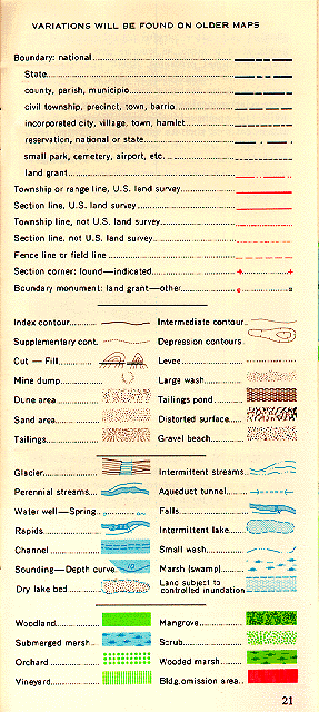 |
|


